
This saguaro is probably 150 to 200 years old. It sits right in the middle of the old jeep road I take to get home. The road most likely started as a route used by the native people. Next ranchers, then hunters. I imagine it's unfazed by a wary cyclist passing on the way home to Dog Mtn.

My Raleigh Super Grand Prix outfitted as the commuter bike.

Mt. Lemmon pictured here. I'm heading East on Tangerine Rd, Gentle Readers, to this light at Tangerine and Thornydale. My morning commute begins with a three mile climb to this intersection.

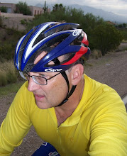
Regarde--Le Randonneur American!
40 percent chance of rain all week, but nothing yet! But it has made the ride nice and cool--only 99 degrees, but a bit muggy.

Okay, so here we are 10 miles into the commute. This light you see is the entrance of Pima Community College and the YMCA, were I would drive and park my car. I must tell you that the 10 miles to here is a bit dangerous, but early in the morning traffic is lite. This little stretch has a sweet bike lane and good pavement, so I gain some speed to make it to the top the hill at Ina and Shannon.

Ina Rd. This is a busy haul-ass commute route for cars. Ina runs parallel to Pusch Ridge which means a steady climb for cyclists. For such a busy crowded road, there are many cyclists either commuting or out training. The climb makes you push; and the rollers are quick and fast. I'm heading East into the rising sun. I must say in this photograph Ina seems oddly void of traffic.

That's Thimble Peak, a Tucson icon, located in Sabino Canyon--a very beautiful place which you must visit when you're in town. I believe the first Spanish explorers had a more descriptive name for this landmark--but it seems to have been lost to time and white men.

America the Beautiful--the wealthy pay a lot of money to have views of Pusch Ridge and the Catalina Mts. Heck, I get to see them on my commute!

Ina changes names to Sunrise and then to Skyline. I've turned around and photographed the way I came. This is looking West. Those are the Tuscon Mts and West of them lies Saguaro Nat'l Park.

Okay. This is the top of Sunrise/Skyline and Craycroft, looking South towards Hopkins Peak. Old Mexico is beyond. My office is about 4 miles away. This is a fast and smooth descent, much needed after climbing all morning.

Going home and making good time. I did start to have cramps in my calves toward the the last few miles. This is on Camino de Oeste, which turns into the un-paved jeep road. It begins the four mile climb to Tangerine and then to Dog Mtn.

The old jeep road through the open desert. It is beautiful and cool, and the aroma of the trees and cactus is a relief from the hot pavement and exhaust from cars. But it is a climb up to the base of Tortolita Mts you can see above, and the trail often turns to sand. I had to walk some but not much.
This trail will intersect with Tangerine Rd. All new paved road with a nice shoulder for bikes. Its a fast descent to Dog Mtn then home.
25 miles into the office, and 25 miles home. Quite the commute...
Cheers! Bruce
No comments:
Post a Comment