
The ride will be just over 200 Kilometers, or on this route, 133 miles.

This morning it's only RBA Susan and myself. A bit cold this morning too, but it should warm up hopefully, mes amis...

My Trek 2.3 is working out well as a quick commuter and fun weekend bike. This Permanent we'll see how it goes as a brevet bike. I've got three water bottles and that should be enough between the controles.

Our early morning start is just on the southern fringes of Saguaro Nat'l Park.

Susan.

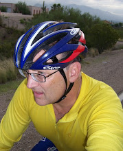
Yours, dressed warm.

We're on Mission Rd, and every Saturday morning, without fail, rolls the famous (or infamous) Shootout. Gentle Readers of This Blog, what ever you feel about the Shootout--it is some awesome fast road-racing! I love it! As promised, I tell Susan she'll get to say she rode in the Shootout with these blokes!

As the police are lurking everywhere to bust the Shootout Riders for so much as the tiny-est traffic violation (at one point a truck was pulling a flatbed so as to arrest and confiscate the roadies en mass) finding a place to take a "break" was a bit difficult. Just when we thought the peloton and the law had sped past--here comes another fast group.

Now for the Brevet Riders to Roll.

Helmet Peak. If you're a Tucson Cyclist, or Arizona Brevet Rider, mon ami, you know right where we are on Mission Rd.

After going through Green Valley kind of the back way, Susan and I are now on the Frontage Rd. that runs along I-19, which goes on down to Nogalas, and the border with Mexico.

Mt. Wrightson is the larger peak in the Santa Rita Range--to the far right on Mt. Hopkins there's a few big telescopes. In the foreground is the formation they call Elephant Head. One thing is for sure, there is snow, and a lot of snow! I believe this is a rare event.

We're rolling into Amado Jct--we'll need to stop and get water and a snack or two before heading west to Arivaca.

I've never stopped in this place but I hear it's not bad. On brevets, we've really not had time to stop and sit down and have burger. I should ask around and see what people say. There's a market across the street where we'll have to get water and fill up our bottles.

We passed through a Border Patrol Check Point on Arivaca Rd.

My beard is about as white as the snow on those mountains--I'm thinking it makes me look too old--and maybe I oughta shave it off. Anyway, this road feels like an old friend. When I first starting riding with Jerry Goode and Dave Glasgow out here, it was usually a lot hotter--and seemed a lot tougher.

On the 400 KM Brevet, this part of the course will test your mettle--after the brutal and forever long-haul on Mission Rd--the Randonneur must tackle these remote and scenic rolling hills for 22 miles--to make it to the controle in Arivaca. This has never been a simple task, mes amis.

This is friendly cafe to stop in and check out--but we really need more provisions down at the store in Arivaca. If you have time, you should ride in and have a coffee or sandwich. They have a restroom that is clean. The service is cheerful and the locals enjoy the visitors.

Get food and water here because there will be none until Three Points--almost 45 miles down the road.

We will ride about 12 miles out past Arivaca until we reach SR 286. We will be under the gaze of Baboquivari Peak as we ride through Buenos Aires Nat'l Wildlife Refuge.

It has been on the cold side today.

We are about 80 miles into our journey.

Left is Mexico, right is Three Points, and Robles Jct.

On this last long leg, Susan and I took turns pulling, to get us down the road. We had a slight tail-wind and that helped out for the ride back.

The road seems to go on forever, but soon we're past Baboquivari Peak--which had a bit of snow on the North Face--which I've never seen before... and now we're looking for the tall radio tower on the horizon, which means we're getting closer.

The sun is going down, and we're not far from the store at Three Points. On the 400 KM Brevet, riders are usually trying to get to the store before it closes--the flashing red lights on the tower can be seen from about eight or so miles out--it's a hopeful sign that this long leg of the ride is almost done.

We can stop and get water and food! And we'll need to get lights set for the short time we'll be riding in the dark. I felt pretty good today, Gentle Readers of This Blog--mostly because I ate and drank enough this time. I've been having problems with the bonk, and Hammer Gel this ride kept me up to speed. Having one extra water bottle helped too--it's important to stay hydrated, even though it was on the cold side today.

The Three Points Store.

This bike's seen a lot of miles, no doubt. I think it's a good representation of the people and the lifestyle out here in this part of the country.

This tower is our landmark. Good to see during the day--at night, such a welcome sight for the Randonneur--water and food, and a brief rest.
Allure Libre
Cheers! Bruce
Allure Libre
Cheers! Bruce