
A friend and fellow Randonneur, Dave Peashock, told me that the Park Link Road was now paved. He had that on authority from Gerry Goode, famed Randonneur from Boston, now Tucson resident.
This road was what Tangerine used to be like not long ago--a remote East-West dirt road used by ranchers. Tangerine Rd links I-10 and Hwy 77, or Oracle Rd., and Park Link connects I-10, sort of, via the Frontage Rd, to Hwy 79. I'm not sure exactly why Tangerine grew and Park Link remained un-developed.
This road rolled around in my mind as I thought it would be a great training course for brevets, and other long rides. The loop I would ride clockwise around the Tortolita Mountain Range would be about 70 miles.

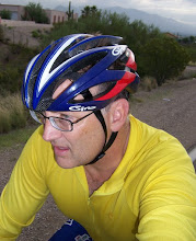
My bike outfitted for the ride. I can carry six water bottles if need be. Two on the bike, two in each saddle bag. Today I carried only three--guess I thought that would be enough--um, wrong.

The weekends are for Callie. She's not sure she wants me to be gone all day--and I won't be; 70 miles is not that far, and the first part and the last part the course are fast. Unfortunately I started at 10 a.m. which is really way too late to start a ride like this--but its all good. Callie is content.

That's Dog Mtn from about 8 miles out. This is where the big Match Play will be next weekend. Tiger Woods will be up here to defend his title. Good Luck, Mr. Woods, and to all the golfers who will play in the tournament.

If you look to the left you can just see the Great Owl's ears sticking up just above the horizon. Next time you're driving from Tucson up to Phoenix, look East and you can see his ears--the owl seems to be gazing West.

I must tell you Gentle Readers of This Blog, that as I rode North on the Frontage Rd next to I-10, there was a pretty foul odor--like manure--and it was very strong--that along with the deafening roar of I-10.

I don't know how well you can see it, mes amis, but there's this green stripe in the lane. I think its from farmer's equipment and rigs hauling manure out to the fields I'm riding past. Saying this is a shitty road is an understatement.

Since Park Link Rd had been re-paved, there's new signs that have gone up. This is good because Park Link is easy to ride past if you're not paying attention. Also, major work is being done on the rail line and I believe it will go to three or four lines from the one that's there now. Mileage from my house puts Park Link at 22 miles. I noted not long ago on a trip up the Phoenix that Park Link is at mile marker 225. On a bike you will see 226 but I've yet to ever see 225 from the bike.

As you enter Park Link, this sign tells you the distance as you head due East. The sign, like everything else, is brand new. This sign was faded before and easy to miss.

Looking West is the Secret Air Base Little Egypt told me about... Oops--did I say that?

In Arizona you will see shrines like this one by the road. I'm been told a few different things about what they mean. There location does not actually mean that a person died here at this spot. It could be that a family member or friend had a vision or profound thought about the deceased at or near this location. Hard to read this, but the soul lived from 1905 to 2003--a very long time. They must have enjoyed a few beers, these friends who put this iron cross here for him, as there's some refreshment left when said soul stops by. Road workers, railroad workers, and city maintenance crews will not disturb these sites out of respect for the Dead. Rest in Peace, mon ami...

Frontage Road I'm on was at one time the stage coach line. The US Army used this route to patrol for Apaches, and the Apaches no doubt observed their movements from Dog Mtn. Millions of people moving at light-speed it seems--

And just to the East where I'm going, the Desert still seems remote and wild and ancient. Mt Lemon with snow dominates the landscape of the background.

Very big changes will be coming here. I feel that with the new paved road, this pristine desert might not last.

This is what it means when you see the "open range" signs with the cows on them. Cattle will be on the road. I saw the few motorists on this road having to stop as they crossed the road. Should you be driving out here, best be careful. If you were to hit a cow your car would be totalled-out and you could be seriously injured by a cow going through your windshield.

Picacho Peak behind me, with no Interstate or rail line or power lines--this is how it looked to the ancient Indians, and to Father Kino in the 1690s when he rode through here on horse-back.

Music on the IPod blocks out the Interstate noise, but soon it becomes quiet, and birds singing and fussing and defending territory and calling for mates fills the hot desert air. It will just be me and a few trucks passing by--cowboys looking for stray cattle.

It is February, but it's quickly getting hot on this road. This route is very desolate--and soon it would be a bit foolish to try to ride this stretch of road because the temps would be murderous. There is nothing from my house until you ride 50 miles to Catalina, Arizona. I must also tell you that the entire 18 miles heading East is a gradual climb--not difficult, but there's a headwind that is hot and dry. Even in February, and when I rode this in December a few years back, I quickly became parched.

A wild hair--but really, its the steady headwind I've got since heading East.

Beginning to get glimpses of the Great Owl's ears. As you get near the Owl Head, things change--and the Desert seems strikingly lush and thick. This is a special place--I am drawn to it as somehow as every living thing is vibrant and alive--the cactus are two and three times larger and taller than other places in the Sonora Desert where I've been. Birds, bugs, bees, butterflies--even the little yellow and purple wild flowers by the side of the road seem to shine more vibrant.

Park Link and Cattle Tank Road. This is the half-way point on my 70 mile loop.

Cattle know where the cattle tank's at--I can't see it.

Picacho Peak about 15 miles West, and still visible. You can also see what I was talking about when I tell you how lush the Desert seems on this road, which you can barely see, mes amis.

Many thousands of saguaro cactus thrive here, as do other desert trees and cactus. There's also a thick layer of bright green grass covering everything like carpet.

Owl Head. It's as if he could up and turn around and see you. I would be like a little mouse compared to his size and might. As you ride, his head seems to turn and look out on things.

Picacho Peak too, changes shape as I weave on this hot winding road.

A new sign--all the signs were new and just installed, like the pavement.

The ears of the Great Owl.

Mt. Lemon with snow.

The road begins to change and the vegetation begins to get sparse. The wind is colder and picking up. There was an adobe style house down a ways on this road. I got the feeling that there was an old farmer living there with his voluptuous daughter--he puts a shotgun in my face and says I'm gonna marry her. While he's calling his cousin, who is a preacher, to come and hitch us up--I quick whisper to the daughter, "How old are you?" and she says something like, "Fore-teen..." and I'm like holy shit I got to get my ass out of here--because she looks like she's 22... But like I said, this part of the road is windy, hot, sparse, and strange.

This is the landmark you need to know. These mailboxes are at the corner of Park Link and Hwy 79. There's no signs so if you're driving or cycling you could miss the intersection.

It is at about mile marker 100 by the looks of things. Here I've just hopped onto Hwy 79. The Junction of Hwy 79 and Hwy 77 (Oracle Rd) will be a long tough climb of 9 miles. In Catalina is where you can stop for water should you need to.

This is just a landmark to let you know you're almost done with the wind, the climb, and the traffic. There's a bit of a shoulder--people drive fast.

This stretch of Hwy 79 has the White Tiger prowling, and he knows I'm here. This is right at or just below the snowline, and from the wind, the cold, and the climb, it seems like your leg muscles are being ripped from the bone. Today I was hurting, but on the 300 kilometer brevet back in early February, my leg cramps were a living hell--I cramped up so severly that the pain almost made me leap out of the saddle!

A few years before that I had to DNF because I had nothing left--leg cramps were so bad that they left me exhausted and trashed, and I limped home and just made it. Today I'm okay because I'm only riding 9 miles on Hwy 79 instead of 22 or so of the 300 km brevet course.

I'm on Hwy 77 and Pusch Ridge is in view. I've got about 25 miles to ride back to my place, and this part through Catalina and Oro Valley will be a much needed descent down to Tangerine Rd.

When I rolled into the garage and off the bike, this little fellow scurried up the wall. He was a bit groggy--and I was surprised to see him. It's still February, right? I caught him and let him go outside in the front garden.
Already a lizard? My, my, what next? Then I began to feel my skin burning--great, now I've a sunburn. Rest day Sunday I hope...
Thanks for riding along. Cheers!
1 comment:
Thanks for sharing Park link, can't wait to do that one. Actually I was going to do that one on my mtb, but way better on a road bike. The remoteness adds excitement, and is something I really look for. Also now you can do a loop, an excuse to go north again. A way to finally avoid Tangerine, and get from frontage to 79. Good details, thanks.
Post a Comment